Catherine Dill
Jeffrey Lewis
May 9, 2014
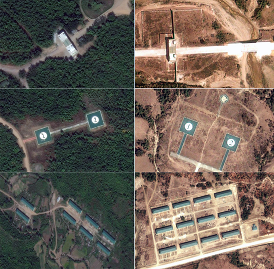
In January, Unity Journal, a weekly publication in Myanmar, alleged that the country has been working on a secret chemical weapons production facility since 2009 in the Pauk Township of the central Magwe Division. The Government has acknowledged that the facility is a standard ordinance factory, but has otherwise denied it is a chemical weapons production facility. We located the facility pictured in Unity using commercial satellite images. Unity released at least three images of the facility. We were not able to locate a copy of the original article, but pictures of the article, including three ground-truth images of the facility, are available on the Irawaddy website. The facility is located at 21°30’4.74″N, 94°21’51.00″E.
Site of Alleged Chemical Weapons Facility, Image ©2014 Astrium
The site in question is clearly a high-value defense facility, as suggested by features such as the security perimeter, barracks-style housing, and helicopter pads. The imagery confirms a number of specific claims by villagers, enough to raise troublesome questions about the country’s commitment to nonproliferation. This is reinforced by the government’s decision to detain reporters from Unity and attempt to confiscate copies of the edition. It is not possible to determine whether the facility is a chemical weapons site, but the facility’s size, layout and location are not consistent with a “standard ordinance factory”. Images of the site from 2004, 2009, and 2012 are available online at Google Earth, Bing and Here. Working with Foreign Policy.com, we purchased a recent satellite image from January 2014. The facility is usually described as being near Pauk township, although there are two smaller villages close to the site. According to the NGIA Gazeteer, these two villages are called Padawgyi and Lebinaing. The story in Unity extensively quoted locals villagers, who complained about confiscation of their farms. The January 2014 satellite image shows that the village of Lebinaing has been razed.
In the left image from 2012, the village of Lebinaing is still visible. In the January 2014 image the village has been razed. Left image © 2014 Microsoft Corporation © 2012 Digital Globe. Right image © 2014 Astrium.
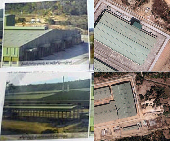
We have high confidence that this is the facility described in the Unity Journal article. We matched all three ground-truth images in Unity to satellite image of the completed facility. The most surprising finding is that the image on the cover of Unity is reversed!
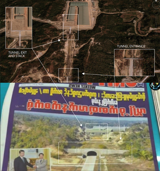
The original image, as published in Unity, was reversed. Top image © 2014 Astrium. Bottom Image © 2014 DVB.
The two other photographs published by Unity also match the January 2014 overhead image purchased by Foreign Policy.
Left images © 2014 The Irrawaddy. Right images © 2014 Astrium.
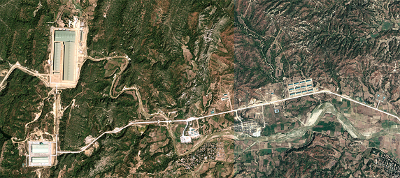
The local sources provided Unity with an accurate timeline of the construction of the facility which began in 2009, just as the Obama Administration was beginning a policy of engagement with Myanmar. A 2004 satellite image shows only farmland, while an image from 2009 shows the beginning stages of work on the foundation of the first building. Images from 2012 and January 2014 image show the facility in the late stages of construction. Locals complained that Myanmar authorities confiscated approximately 12 square kilometers of farmland. Although the facility sits on about 1 square kilometer, the surrounding farmland at both sites and along the main access road where housing was constructed is consistent with a total land use of 12 square kilometers. The site comprises five large warehouses totaling around 200,000 square meters. Three of these warehouses are together in the Northern part of the site, while two more warehouses are at the Southern part of the site. The Northern and Southern areas are connected by a tunnel 630 m long. The site has a number of signatures associated with a high-level of security. Perimeter fencing around the buildings and a fortified entrance to the facility are visible in the images. Local residents told Unity that the site is heavily guarded and that workers are not allowed out.
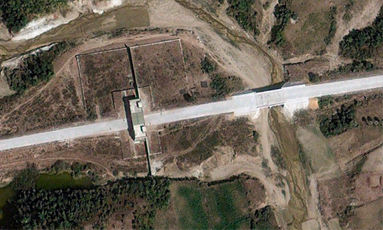
Secured entrance at facility. Image © 2014 Astrium.
There is also a helipad near the facility. Burmese leaders use helicopters to travel around the country. Local residents reported a stream of high-level visitors to the site, including the former Army Commander-in-Chief Senior General Than Shwe, current Army Commander-in-Chief Min Aung Hlaing, former Vice President Tin Aung Myint Oo, and current Vice President Nyan Htun. The helicopter pad is consistent with this reporting. A similar helicopter pad is visible at a site linked to North Korean project to produce surface-to-air missiles, near Minbu.
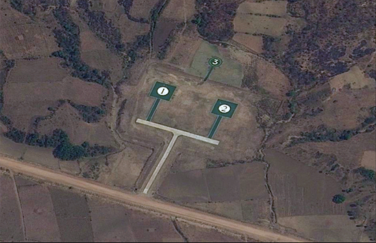
Helipad near facility. Image © 2014 Microsoft Corporation © 2012 Digital Globe.
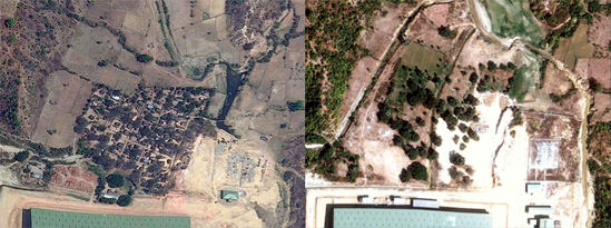
Finally, there are a number of structures that appear to be housing for local and foreign workers. Myanmar cleared an area between 2004 and 2009, constructing a small village that appears to house Burmese workers for the site.
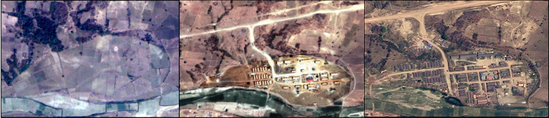
Images of the worker housing area from 2004, 2009, and 2012. Left image © 2014 Google © 2004 Digital Globe. Center image © 1987-2013 HERE © 2009 Digital Globe. Right image © 2014 Microsoft Corporation © 2012 Digital Globe.
The January 2014 satellite image also reveals barracks-style that may be for foreign workers. Locals told Unity that the Pauk facility is staffed by Chinese. We are skeptical that China would assist Myanmar in constructing an illicit chemical weapons facility, but the housing does seems consistent with that dedicated to foreign workers.
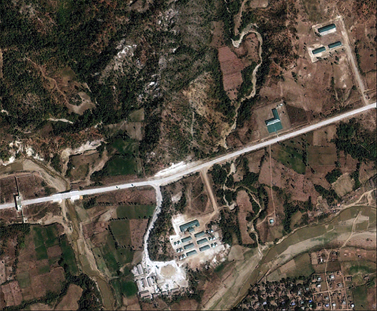
Barracks-style housing, possibly for foreign workers. Image © 2014 Astrium.
All three features — the security gate, the helipads and the barracks-style housing — are similar to another facility near Minbu, which is reportedly staffed by up to 300 North Koreans. (The Minbu facility is located at 19°59’42.66″N 94°27’31.90″E. We dropped you on the helipad; you can drive around.)
Features of the facility near Pauk (right) match those of a suspected North Korean missile factory near Minbu (left). Left images © 2014 Digital Globe. Right images © 2014 Astrium.
It is difficult to determine much more about what is being produced inside the factory buildings. Local residents claim that the facility is staffed by Chinese technicians and produces chemical weapons. Myanmar officials deny it is for production of chemical weapons, but will not say what the purpose of the facility is or whether China, North Korea, or any other state is involved. Based on the overhead imagery, we cannot determine the purpose of the site. Some features are consistent with a chemical plant such as the location and what may be ventilation systems. The facility is nestled in hills, which may provide some protection for nearby communities in the event of a chemical release. Similarly, the connected buildings in the northern part of the complex have what may be exhaust stacks and roof vents that may be for ventilation. There are a small number of tanks visible in the Southern area, while the buildings in the Northern area are connected to one another, suggesting a long process line.
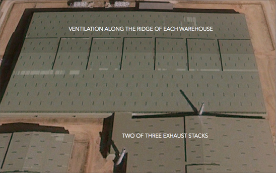
Possible ventilation at facility. Image © 2014 Astrium.
A number of the details provided by local residents, including the level of security, presence of foreign workers and visits by high-ranking officials are consistent with the images of the facility. What remains is a large, high-value defense facility with no transparency about its purpose that is alleged by local residents to be engaged in the production of chemical weapons. Until Myanmar completes it long-delayed ratification to the Chemical Weapons Convention (CWC), the international community has no mechanisms by which to determine whether the facility is engaged in the production of chemical weapons. In light of the recent allegations and the available satellite imagery, the international community should insist that Myanmar ratify the Chemical Weapons Convention without further delay and clarify the purpose of defense activities at the Pauk facility.